Tuesday, April 22, 2014

Rannerdale Knotts

heading up the track that goes to Whiteless Pike

In the double-entry system that is a record of one's fell running, I can take credits for getting out for a run after initially deciding not to bother; for bagging a Wainwright; for getting five miles in on the fells with a 7pm start; for beautiful Buttermere valley scenery with atmospheric clouds; for escaping rain and for exploring a few new tracks.  When compared against changing the route due to impending darkness and cloud, I feel the balance is overwhelmingly positive.

In other words, great to get out for a run this evening.  Some indecision meant that we didn't set off until 7pm and so our original plan of heading up Whiteless Pike, around and down Red Gill on Grasmoor was changed to a shorter run taking in Rannerdale Knotts summit.  We still had a good run though, the track along the ridge of Rannerdale Knotts is a good testing run with a nice technical descent down the steep part.  The Buttermere valley was beautiful tonight.

fading light meant a decision to turn around.  "Hey, how about running along there?" Nice running along to Rannerdale Knotts summit from the turnaround point on Whiteless Breast

Jonathan coming back down the trail.  Whiteless Pike and cloud behind

Rannerdale Knotts summit looking over Buttermere lake towards Haystacks

steep descent

five good miles


Monday, April 21, 2014

Glencoyne Loop

Jonathan working his way up Glencoyne Brow

new Ullswater path
I've been exploring Glenridding and the surrounding area lately.  It's a beautiful area.  One of the, previously hidden gems I have found is the path along the wall along Watermillock Common.  It's mostly downhill, but at an easy gradient for the most part, with some runnable uphills.

After a bit of experimentation, I put together a great route, climbing up Glencoyne Brow, running along Watermillock Common and then down to Ullswater shore along the Aira Force track.  After the initial steep climb, it's all runnable, gentle (for the most part) downhill and single track or wider stone paths like the one in the picture on the left.

Overall it was just over five miles.  A very pleasant run on a sunny evening.


Scafell from Eskdale

David's photo of me on top of Scafell

looking back and zooming in on the Eskdale Needle on our long way in to
 Scafell.  Have a look here for some pics of a walk David and I did here.
It's been a while since I've had a walk with David.  He's a keen photographer and has had many pictures published in various magazines.  He also has a Facebook page, The Wainwright Fellwalker that you should check out.  Here is a link to the pictures he took on this walk.

Today, David was keen to explore views from Eskdale and Great Moss towards the Scafells.  I was keen to explore a bit of Scafell.  David's mate Alastair came along too.

David in front and Alaister behind heading up the valley
Eskdale is wilder and remoter compared to the other approaches to the Scafells.  The river Esk snakes photogenically along the valley.

Today, conditions were very dry.  It's an expectation to get quite wet going across Great Moss.  Today, we only got a very little bit wet and it was possible to walk across the middle of the moss, something that would usually leave you wading at least ankle deep.

We started at Brotherikeld Farm and followed a nice route along the river, looking up to the right trying to pick out the Eskdale Needle on the flanks of Hard Knott.  The path was fairly level until we crossed Lincove Bridge where it rose steeply to Great Moss.

David spots Scafell Pike and Ill Crag

first of many river crossings
We had to cross the river a few times to get over to Cam Spout Crag.

I knew we were in for a bit of hanging around in Great Moss while David tried to get the perfect shot.  I didn't mind too much, my feet were a bit tired from a big day out the day before and it was nice to sit in the sun near to Sampson's Stones while David went off photographing.

Eventually David came back over to meet us and we headed off up the rocky Cam Spout route.

After many stops and frequent altitude checks, we reached the gulley that goes up to Foxes Tarn.

David and Alastair pass by some of Sampson's Stones.  Scafell Pike is middle left.

taking a break on the steep rocky ascent up Cam Spout

After a long, hot climb, eventually the ground evens out a bit.  Looking up to Mickledoor, the col above this group of people, and Broad Stand on the left.  Our route up today was via Foxes Tarn along a gulley in front of Broad Stand.  We would then carry on up to Scafell and, after a bit of exploration, come back via Lord's Rake crossing back over Mickledoor and down this same way.

climbing up to Foxes Tarn 

Foxes Tarn - still a fair bit of climbing from here up scree
The climb up from Foxes Tarn is up a winding path through the scree.  We took it easy and broke it down eventually topping out and heading over a short way to the summit.

Views from the summit were extensive.  I would really recommend that you have a look at David's photo's.

We looked over to Scafell Pike where there was a mass of people on or near the summit.  Scafell, in comparison was quiet, we met a few people, one of whom was finishing his Wainwrights there.

After pictures at the top, we headed over to Deep Gill.  This is the entry to the West Wall Traverse which was our planned route around and down.  When we got there, we saw that it was filled with snow and so decided against this route.

a busy Scafell Pike

Mosedale and beyond

Wasdale

I've seen that pose somewhere before

The Pinnacle at the head of Deep Gill

of course a great man has been here before

and a not so great man ;)

David had a bit of fun recreating the Scafell 9 page from Wainwright's guides and then we went to have a look over Broad Stand.  The famous drop made by Lord Byron.  I was a bit wary of getting too low down on the crag but I would like to go back with someone who knows what they are doing to see exactly how difficult it is.

This 3d view looking along from Mickledoor shows where I dropped down to look at Broad 
Stand before coming back and heading to Mickledoor along Lord's Rake.

So after a bit of playing around Deep Gill and Broad Stand, we headed over to pick up Lord's Rake.  There is a cross at the junction between the paths to the summit and Foxes Tarn, I think the remains of a shelter, and one of the arms points in the direction of Lord's Rake.  We headed down the winding scree path and then began the drop down, across and down again before the final climb up the climber's track to Mickledoor.

about to tack the last climb up and famous chock stone
there is that famous stone.

cautiously underneath

this picture gives some idea as to the size.  Alastair is just above the middle patch of 
snow with David behind.

looking back from Mickledoor along to Lord's Rake

So after descending from Mickledoor, we headed back the same way we came.  A great day out, about 12 miles in total.

close up 3d of our wanderings around Scafell

and the flat map

the full route


Friday, April 18, 2014

The Old Crown Round Fell Race Route

popular day on Skiddaw

A red hot Good Friday was the day we chose to have a crack at The Old Crown Round fell race route.  The route exists in different guises but the premise is that you visit fells that have a beer named after them made by the Hesket Newmarket Brewery and served in The Old Crown Pub.

route and elevation - 22 miles all in

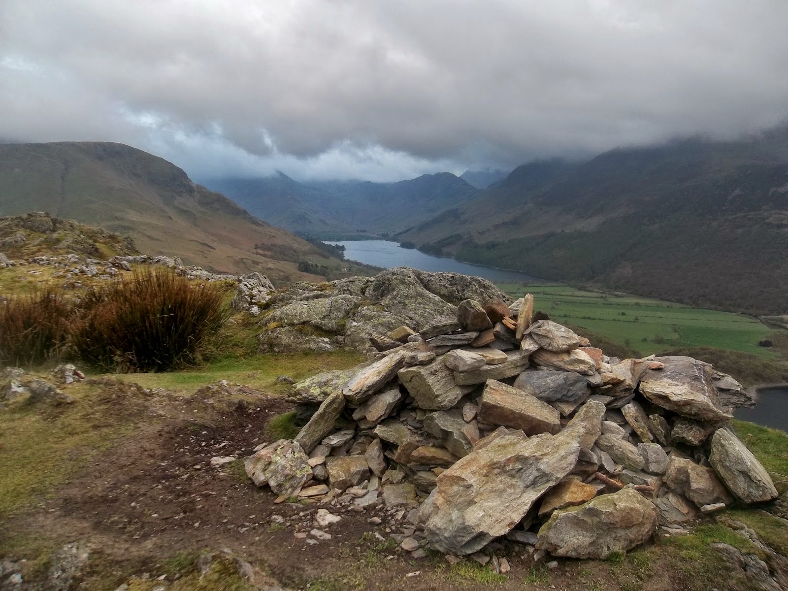
Apronful of Stones - our track up is the one on the left
The race starts and ends at The Old Crown pub but we decided to start and end at a place called 'Apronful of Stones' at the bottom of the track leading up to Carrock Fell.

This is a fairly steep initial climb but then the gradient evens out.  It was cool as we set off, at about 8.30am, but we soon warmed up.  Conditions were very dry making it easier going than the last time I was here in full waterproofs, low cloud and midgie swarms.

Being Good Friday and hot, there were lots of people out and we met the first few on this initial climb and then another person at the summit.


Carrock Fell looking over to Bowscale Fell, our next objective

Heading down from Carrock Fell, Paul guided us on a decent route avoiding the gorse and worst of the rubble and scree.  We danced around a bit looking up and down the river before deciding there was no ideal part to cross and that we should just paddle across.  I wasn't too happy about getting my feet wet so early but there was no other alternative.

at Bowscale Fell looking back to Carrock Fell
Once across, we took it easy on the climb to Bowscale Fell and then took in the nice easy descent to the path junction where you begin the climb of Foule Crag.  Looking over at the mass of people on Sharp Edge, I said to Paul that I had never been over it, so we decided to cut across and head up Blencathra that way.

There were throngs of people crossing Sharp Edge.  Who can blame them, it was ideal conditions, dry with no wind.  I enjoyed going this way, another thing to tick off the list.

Soon enough we were at the top and then we headed down.  We set off descending towards the Cloven Stone but then Paul suggested heading down the gill to the Cumbria Way track.  We did this and aimed our exit onto the track just right, coming out at a bridge about a mile from Skiddaw House, our next point.  Lots more people to say hello to on this track.

Paul tries to count the people on Sharp Edge

zoomed in

looking down to Scales Tarn from Sharp Edge

sharp edge


looking down Hall's Fell Ridge, famous Bob Graham Round descent route from Blencathra

bank holiday Blencathra summit

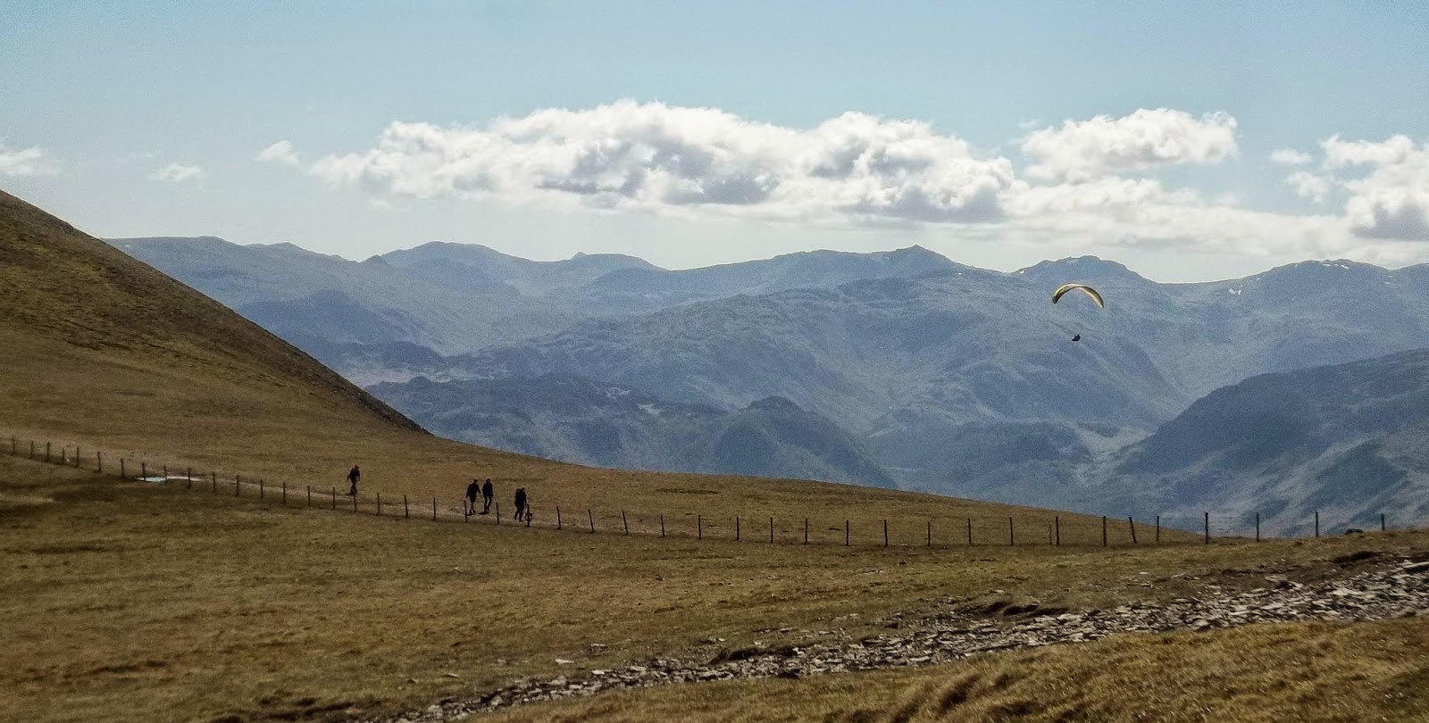
at the top of the Sale How track looking south to Skiddaw Little Man, a paraglider and lots of fells

up to Skiddaw
The climb up and over Sale How to Skiddaw was difficult.  I've come down this track before and it's a brilliant descent but today, in the heat and with miles already in the bag, it was tough going.  We took it easy, had a few stops, fuelled up and eventually got up to Skiddaw.

We watched a paraglider effortlessly float around above Skiddaw Little Man then joined the bank holiday crowds on the top.

Skiddaw summit
The descent was via the Bob Graham track down Blake Hill and Hare Crag.  A fast descent in good conditions and then another climb up to Great Calva.

This track is always wet but we trudged it out and eventually got to the top.

Great Calva was windy on top.  We checked the map, I adjusted my shoes and socks which hadn't really been right since crossing the river earlier and then scoped out the rest of the route.  The track to Knott looked very manageable.  It was, but it did get steeper as we got nearer.

Great Calva
From Knott we picked out indistinct tracks to Lingy Hut, a bothy type shed building on Great Lingy Hill.  We checked the hut out, I signed the guestbook and then we continued on over on the Cumbria Way.

After not too much more time, the welcome sight of High Pike, our last fell, rose up from the horizon and we trotted up the path to bag the summit.

There is an old mine track that takes you nicely along Carrock Beck and back to the road.  I thought that this would be a nice end to the run but actually found it tough going as my legs were so tired.  
A short run up the road took us back to the car and completed the run.

Knott summit, looking back to Great Calva in the middle, Skiddaw on the top right, Lonscale Fell behind Great Calva on the left.

Lingy Hut


High Pike, last fell - well done Paul!