 |
| top of Skiddaw - middle of the night |
It's some time around 2am on the morning of my 42nd birthday. I've just been climbing back up a slippery scree slope near to the top of Skiddaw, the fourth highest fell in the Lake District. The top of Skiddaw is a barren affair, rocky with shelters and cairns dotted around. I think it might have been in contention as a location for the filming of the moon landings.
It is obviously dark at this time of night, but thick cloud and a substandard headtorch confound my navigation further - the weak beam bouncing off the cloud. I can just about see past my feet. Add in the fact that I have been on these feet for some 16 or so hours and 40 odd miles, 14,000 or so feet of elevation, and you have some idea of my situation. And I'm loving it! I really am loving it. I feel like I could go on forever.
It all started in 2010. I had spent the last few years getting into shape, losing weight, starting to run, learning to swim, eating right, basically sorting myself out. For my 38th birthday I wanted to find some way of celebrating without the usual excess and debauchery. I conceived
The Birdathlon, a self-supported multisport event based loosely around the number 38. This was the first ever post on my blog. Yes, this is where it all started.
Since that time, I've had all kinds of adventures and hilarity has invariably ensued. I've tried cycling, triathlon, road running and have graduated towards fell or trail running. Of late, I've become interested in long distance stuff. I will be doing the St Bega 35 mile race in a few weeks time and in September, The Cumbria Way which is about 73 miles. The Cumbria Way entry wasn't planned. I won it. Winning the chance to punish yourself over 73 miles might not seem much of a prize but entry to these events is always, understandably, expensive and I am very grateful for a free entry.
One of the first things I did was consult
Relentless Forward Progress, a classic text in ultrarunning. I jumped into a plan for a 100 mile race, I was already putting some decent mileage in so it did not mean a massive increase for me. The plan had a 50 mile race for this weekend. Running 50 miles on my birthday weekend intrigued me. I looked around for a local 50 mile race. They're not all that common.
About six weeks ago, I had the honour of running the last leg of
Steve Birkenshaw's legendary round of the complete Wainwright fells. Prior to the run we had been to see Steve talk about his run at the Keswick Mountain Festival. He showed a video of his intended route. I was spellbound. Steve talked about previous attempts at the record.
Joss Naylor was then the record holder with a time of just over 7 days. At Keswick, Steve talked about previous attempts at the record, how he was going to gain time on Joss by resting less and taking a better route. He also talked about somebody who had attempted to do a book a day (The Wainwright guides are a set of seven books covering the different parts of the Lake District). Shortly after this I started drawing squiggly lines on maps. I remember a Facebook post about the Ellenborough Running Club doing the North Western Fells in one go. This was my first option. It is all familiar ground and quite easy route finding. I was put off a bit by the repeated complete drops down to road level. In the end, the deciding factor was that I couldn't work out a nice loop. I could only make a linear route, starting at Sale Fell and ending at Castle Crag (Rosthwaite). I would be dependent on someone dropping me off or picking me up and I didn't want to be.
I had a look at the Northern Fells. A route was fairly easy to pick out, and a circular route at that. Binsey was always going to be a bit of a pain, being a few miles separate from the other fells. I remember Steve Birkinshaw commenting on this and hearing that it was one of the sections he found the most mentally challenging on his actual run. My other concerns were relatively tough terrain compared to the North Western Fells. The Northern Fells being more grassy, more up and down where the North Westerns have rocky, well defined paths, many along long ridges, to run the length of. Navigation would also be a bit more difficult, particularly around Knott and the surrounding fells. We've got some form on
getting lost on Knott. Finally, my route had the tough climb up Bakestall and on to Skiddaw, a climb I detest at the best of times, right near to the end and then an out and back to Lonscale Fell, again something I'm not keen on. With all this in mind, The Northern Fells still seemed like the best option.
So I set off on the day before my birthday at about 10am from Latrigg car park to have a crack at the complete Northern Fells.
 |
| looking back to the car park from the first small climb up to Latrigg. The main track up Skiddaw can be seen on the right. If all goes well, I would be avoiding this path which is a leg deadener at the best of times but 40 odd miles in was going to hurt. |
It's a very small climb from the car park up to Latrigg. The path winds around the fell but a more direct, but still easy, route can be taken straight over. There was a runner on top of Latrigg looking out over Keswick. He took the same track I was going to take down towards Brundholme. "I'm sure I have a lot longer to go than you" I thought, so I was happy not to try to keep up with him.
 |
Looking over to Blencathra from the top of Latrigg. Blencathra was one of the bigger climbs of the day and it would be good to get it out of the way early.
|
 |
| great views over Derwent Water from Latrigg. A good family fell. There is even an 'accessible' path up to it (I would want off road wheels) |
Once through the gate and onto the road from the track east from Latrigg summit, there is a signpost pointing towards Derwentfolds. This track goes towards the Blencathra Centre and on to the path up Blease Fell, over Knowe Crags on to Blencathra. The forecast for the day was heavy showers with potential for thunderstorms and the cloud was closing in on Keswick as I climbed the long winding path up Blease Fell.
 |
| looking back from the winding Blease Fell path on the way up Blencathra. Cloud coming in over Newlands and Keswick |
 |
| beautiful Blencathra's craggy south/east side |
 |
| Summit of Hallsfell Top/summit of Blencathra. This ring stone must have been put there since Wainwright completed book five in 1962 because he says that nothing marks the top. The Skiddaw group (some of my final planned fells today) are starting to get covered in cloud and look a long way away. I'll be moving in the opposite direction for a good while yet. |
I took my time climbing up to Blencathra. Once at the top of Blease Fell, there is some levelish ground along the top and then a nice run down. I veered off to the left of Foule Crag picking up the muddy track towards Mungrisdale Common about a mile from the summit of Blencathra. There was a chap there having his sandwhiches,
"Can I take it that you are doing the Wainwrights?" he enquired.
"I've finished the Wainwrights, I'm doing a run today based on some of them." I said, not wanting to show off, or actually be too confident, as I was only about six miles in at this point.
"You mean you've been here before? And you came back?"
 |
| Mungrisdale Common cairn. Grumpy bloke leaning against it eating his sandwiches cleverly cut out of the photo |
From Mungrisdale Common, another track heads east. Again it is muddy but eventually meets up with the col where paths cross to Blencathra (Foule Crag), Bannerdale Crags and down the Glenderamackin valley. I took this path, crossing over and climbing up towards Bannerdale Crags. I met a family at the top, the two children wanted to put rocks in their bags to carry back to their car. I stopped and chatted for a while. They were heading around the path on The Tongue, the same path I would be going up after Souther Fell.
I stopped for a bit at the cairn and tried to sort my shoes out. The insole was slipping due to being wet. I didn't really sort them out and ended up taking them out further along on Souther Fell.
 |
| Bannerdale Crags looking towards Blencathra |
 |
West spur cairn on Souther Fell looking towards the crags of Bannerdale Crags and Blencathra beyond
|
I had planned a direct route from the summit of Bannerdale Crags towards Souther Fell. However, when I saw the steepness of the climb up Souther Fell, I decided it would be better to contour around. I carried on over Bannerdale Crags, taking the most gradual way down to the river and across the footbridge onto the path that goes up and over Souther Fell.
 |
| summit of Souther Fell in the same direction |
I followed the ridge path a little way over and down towards Mungrisdale before turning to drop steeply down the side of the fell. At this point, I took the insoles out of my shoes as they were getting bunched in the toes. I crossed the river and got onto the path up The Tongue. Halfway up I bumped into the family I had met on Bannerdale Crags. "Did you hear that thunder?" the mother said. The kids thought it was great but I think the parents were glad to be heading down.
At the top of the ridge, the first heavy shower hit. There was a bit of thunder rumbling around and some lightening in the distance. I got my waterproofs on and then headed quickly over the top of Bowscale Fell, glad to start dropping down towards the valley.
 |
| Bowscale Fell summit, looking back towards Blencathra now in cloud - not hanging around up here |
 |
| crossing the river Caldew, always a messy affair |
Down at the river crossing, as usual, there wasn't a dry option to cross so I found somewhere shallowish and waded across. I filled my water bottles from the far side and then did my best to pick a decent way up onto Carrock Fell. Heavy bracken cover made going very tough but I just kept going and eventually got onto flatter and less rough ground. I headed over to the cairn and then turned back on the main path over Miton Hill towards the Cumbria Way path.
 |
| summit of Carrock Fell |
 |
| looking up towards High Pike which is covered in cloud |
 |
| misty High Pike summit |
 |
| Knott summit |
I crossed over the Cumbria Way path and headed up and back down High Pike. From this point on the cloud really rolled in making navigation more difficult and progress slower.
This was exactly the part of the Northern Fells that I thought would be more difficult to navigate on. I used landmarks to find my way, following the Cumbria Way path then turning off towards Knott.
Knott is a fairly central fell in the sense that other fells branch off from it. I was fairly sure that, if I carried on climbing in the right direction, I would get to the top. Sure enough, I came to Knott's familiar pile of stones without much fuss.
From Knott, I was able to find my way over towards Meal Fell and then Great Sca Fell, all quite close together.
 |
| Meal Fell summit - temporarily cloud free |
 |
| Great Sca Fell |
After leaving Great Sca Fell, the cloud cleared, enabling me to see the grassy track towards Brae Fell. I sent a text message to Jonathan who was due to meet me at Binsey. I was about an hour behind schedule. He had a run up and down Binsey while he was waiting.
 |
| Track towards Brae Fell |
 |
| Brae Fell summit |
From Brae Fell, I had to go over to Longlands Fell and then down onto the roads for a few miles to Binsey where Jonathan would be waiting. it might have been easier to go back along the track and contour around but I took a more direct route, climbing steeply down into a gully and back up again.
 |
| Longlands Fell. Binsey is the round fell in the distance and is my next objective. A bit of road running to get there |
I was dreading running the out and back on the roads to and from Binsey. When it came to it, it wasn't too bad. I think knowing that food and refreshments would be waiting for me helped me. Jonathan was a very welcome sight (not often I would say that) waiting at the bottom of Binsey holding out a Snickers and a bottle of coke. I stood and drunk the coke and it gradually dawned on me that an Ashworth was in process: he was saying that he wasn't going to come with me as planned (and agreed!). I think I could haver persuaded him but there was a big part of me that was enjoying the solo effort so I took his Ashworthing lightly and turned it to my advantage by taking his shoes, socks and energy bars off him. I was about 27 miles in at this point and it was clear that I would be running into the dark if I was going to finish. I think I was very positive. I knew how disappointed I would be in myself if I got in his car so the thought hardly entered my mind. Jonathan drove off and I set off up Binsey. Feeling strong and confident.
 |
| aid station |
 |
| most of the remaining fells from the climb to Binsey |
 |
| Binsey, not a bad place to witness the sunset but tonight I wanted to get as far as I could before dark |
 |
| looking back towards Binsey from the track towards Great Cockup |
The headtorch was needed from the climb up to Great Cockup. I was really hoping to get Great Calva (the next fell) out of the way before it got too dark but it wasn't to be. I noticed my headtorch was quite dim. I changed the batteries and it didn't get any brighter. First minor worry about headtorch.
 |
| Great Cockup - I think that's Overwater in the distance |
Great Calva was easier to find than I thought. I could see the outline of Skiddaw and a few headtorches going over the top. It was a case of finding the col on Burn Tod and then going south until I got to the fence. From the top, I took a direct line down the horribly lumpy descent from Great Calva Summit to The Cumbria Way.
 |
| Great Calva Summit |
Once on the Cumbria Way, the route finding was a bit easier, consisting of a lot of handrailing. I filled up my water bottles at Whitewater Dash and then followed the wall up to Bakestall. This was a tough old climb. It's tough at the best of times but in the dark after 40 odd miles, urgh!
 |
| Bakestall |
In comparison, the climb to Skiddaw wasn't too bad. I carried on over to Little Man and then over to the track where I followed the fence to Lonscale Fell.
 |
| Skiddaw top |
 |
| Skiddaw Little Man - lights of Keswick visible |
 |
| Lonscale Fell |
At Lonscale Fell, I was confident I was going to finish my challenge. I had dreaded the climb back up to Skiddaw but it was fine. When I got to the Jenkin Hill path junction, I saw that heavy cloud had set in on Skiddaw. I picked up the main path and was a bit worried that my headtorch just seemed to be bouncing off the cloud. It was very thick. On reflection, this is where I should have stopped. I followed the path, hugging the edge until I got to the second gate. I couldn't see anything so decided to have a go at dropping down to the height of Carlside (the next fell) and contouring along. I dropped down, it seemed too steep, so I went back up to the fence. I tried again, no, don't like that, back to the fence. I sat down for a bit with the map, checked myself and decided to go for it. I dropped down, contoured along. Looking at the gps track now, I was pretty much bang on target, but I wasn't confident so I headed back up and back up to the fence. I sat at the fence for a while and considered my options. If I found Carlside, it's a proper ridge along to Longside Edge and Ullock Pike with the potential for very serious falls if you step in the wrong direction. I considered getting in my emergency shelter for a few hours until it got light but thought better of it. I realised then, and I'm so much more sure of it now, that the correct decision was to call it and head home. I followed the fence back down over Little Man to the main path. When I fell off the side of the main path (which is remarkably built up at the edges) I was even more sure that I made the right decision.
I carried on down the main path, rejoicing at reaching the various gates, getting back to my car at about 4am. I went to Tesco for refreshments and was home and in bed for 5am. At 7am Hannah, my eldest daughter shouted, "I have two things to say, first: Happy Birthday Daddy!, second: can I have some breakfast please?"
 |
| navigational conundrums on Skiddaw |
 |
| back cover of Book Five showing the Northern Fells. The orange line is the bit I never managed. |
.png) |
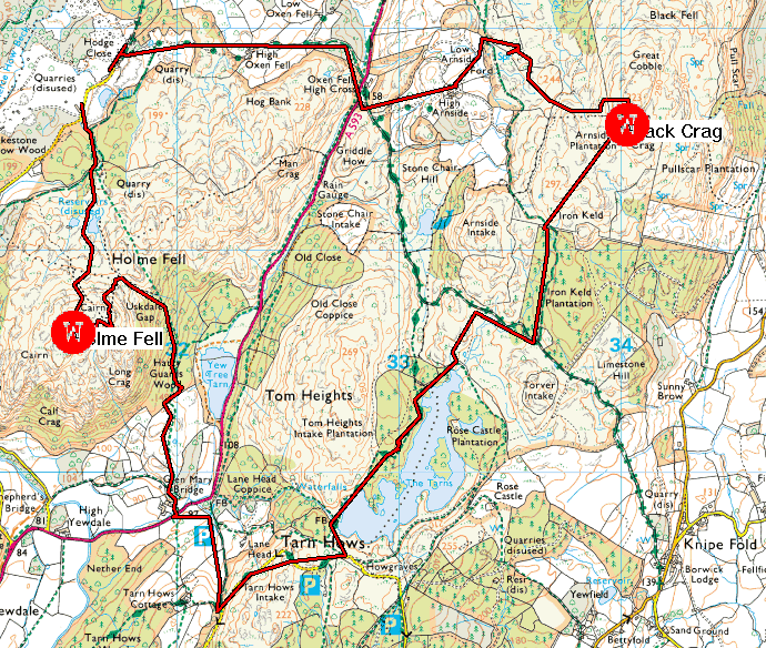
| GPS track of my route, quite similar to my original plan, the only differences, apart from the final section, being a more contoured route rather than direct up and down. A flag is a Wainwright top. The blue crosses are points to refill water bottles. Jonathan can be seen at the bottom of Binsey (top left of map). |


.jpeg)
.jpeg)