I'm on paternity leave! Our daughter arrived on Monday morning. This means that I get a week off work and am able to do loads of walking and running. What it actually means is that my wife is wonderful and told me that she was quite happy for me to, "go and play"
 |
| 12.5 miles in total |
 |
| Skiddaw from the climb up Kinn |
I had a run planned around Kentmere but as I got a late start, I decided to head somewhere a bit closer and more familiar. I set off towards Braithwaite, parking just next to the Royal Oak. After messing around trying to get my iphone to play (duff earphones), I set off up the Whinlatter Road. At the second car park/layby, head up the stepped path which takes you to Kinn and on to Sleet How. The path to the left will take you on the track to Force Crag Mine. This can be a good path to take back if you get tired or starts to get dark.
 |
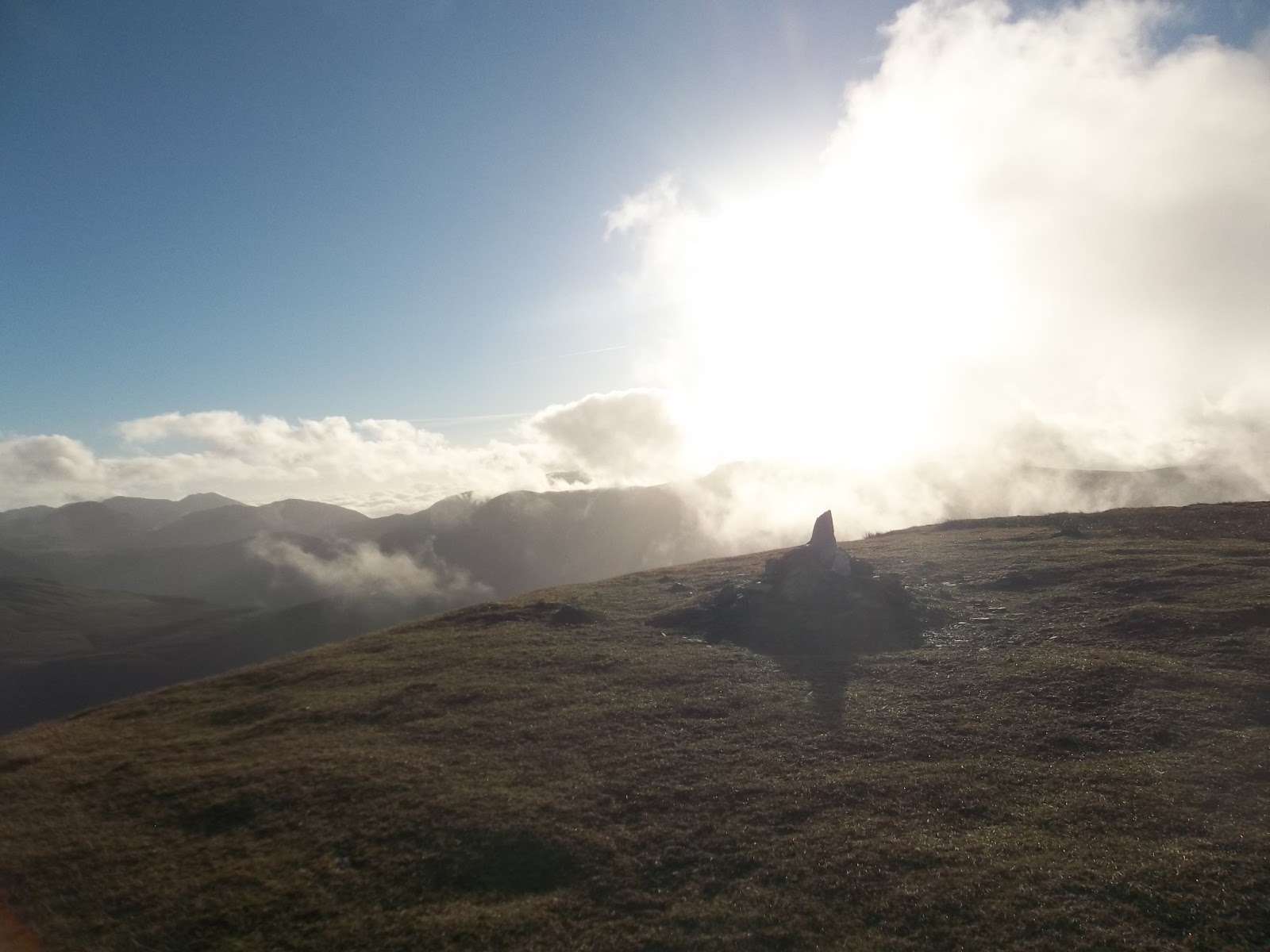
| looking back to a floating Skiddaw from the first climb |
An ex-work colleague of mine used to run the Grisedale Pike loop whenever he could. He got up to 200 times before he moved to Scotland. I can see why he liked it so much. I also appreciated going somewhere familiar today, where I did not have to worry too much about navigating.
Today was also officially the first day of the year where I was confident enough of the weather not to take waterproofs. Thw forecast was for clear weather with great visibility, very little chance of rain.
It had been a really clear night, with a frosty morning.
Even at my late setting off time, there was plenty of hanging cloud in the valleys.
Cockermouth, which I pass through on the way to Braithwaite/Keswick, is often shrouded in mist and today it was very thick. A run up and over the tiny Sale Fell would have got me up above the cloud with some great views of Skiddaw but I had a bit more time and Sale Fell is a quick after work type of fell with no easy options for extending to a longer run.
The mighty Skiddaw looked amazing; just like the last time we drove past, it had cloud rolling over the edge. It would have been brilliant to run up there and I considered changing my plans but stuck to the original one and kept on towards Braithwaite.
 |
| looking towards Barrow Door, one of the options for a return route |
 |
| Wiggly topped Causey Pike prominent above Barrow Door |
 |
| looking back down the trail, Skiddaw still above the cloud |
 |
| my return route is over there somewhere |
The climb up to Sleet How is a bit of a slog but was broken up today with the wonderful views behind of Skiddaw. As I climbed higher, I got my first views of the mighty Grisedale Pike. I always think that the Coledale Horseshoe is pretty level once you get to Grisedale Pike. I was telling myself that the remainder of the run would consist of pleasant ridge runs over gently undulating peaks. I was wrong.
 |
| first view of Grisedale Pike |
Wainwright devoted 16 pages to Grisedale Pike in Book 6, The North Western Fells. Deservedly so I say, it's a fine fell; very striking and recognisable with it's strong angular profile, it can be easily picked out from the A66 heading west towards Keswick or from the top of Skiddaw.
 |
| the climb up to Grisedale Pike - the picture doesn't do it justice |
Now onto the final climb up the rocky corner of Grisedale Pike. I met a couple here who had stopped for a pork pie before taking on the ascent. I continued on. I have completed this climb a few times and ran down it once. The run down is very pleasant, especially when you get onto the flatter ridge at Sleet How. Today I was walking into the sun and, as I got a bit higher, it became quite cold. Time for a hat and gloves which stayed on to the end.
 |
| a nice run in the other direction |
 |
| last look back from the climb |
 |
| from the summit looking towards Hopegill Head and Ladyside Pike |
From the top of Grisedale Pike, there is a nice undulating run along the ridge to Hopegill Head. A broken wall seems to have turned into a path over the years, although it's easier to run alongside on the grass. There are a few little bumps before a very tempting path leads up again to Hopegill Head. I had the sunset in mind today though and Hopegill Head was the peak I opted to leave out in order to keep to a decent schedule. Instead, I crossed down to Coledale Hause and then headed up to Grasmoor.
 |
| the wall/path |
 |
| climbing up to Grasmoor, cloud getting interesting |
 |
| branch to Wandope and Whiteless Pike |
The path up to Grasmoor from here is wide and clear. There are a number of cairns marking the way but in clear weather, there are grassy tracks (as opposed to the main path) that are nicer to run on. I took a path along the northern edge which gave good views down into Dove Crags and over to Gasgale Gill on the other side of the valley.
 |
| Gasgale Gill |
The views from the top of Grasmoor are great. Today there was cloud rolling in but, in general, it made the views more exciting. I ran around on top for a bit, taking pictures in different directions. I had a quick chat with a man and his two dogs before heading back down towards the crossroads and heading up to Wandope.
 |
| from Grasmoor summit. Whiteless Pike ahead, High Stile Range over the way |
 |
| Grasmoor summit shelter |
 |
| right in front is where I'm headed next. I need to double back first though |
 |
| climbing to Wandope, looking back to Grasmoor with cloud coming in |
Wandope and Whiteless Pike were my main objectives of the day. Bagging these two Wainwrights would mean that I finished Book 6, The North Western Fells. Wainwright lamented that many walkers don't know Wandope is there. Indeed, from the approach, it just looks like a slightly higher area with a cairn. The path leading up is the only real clue that there is something of note in this direction. However, once at the summit cairn, the views down over Sail Beck and the crags of Scar Crag and Addacomb Hole are quite something. The rolling cloud added drama today.
 |
| Wandope summit cairn |
 |
| over to the Ard Crags/Knott Rigg ridge |
 |
| and again, nearer to the edge |
 |
| Ard Crags and Knott Rigg with the round dome of Robinson behind |
From here, I headed over to Whiteless Pike, the last of Book 6. Like Grisedale Pike, the path looked a bit easier than it was. There is a substantial dip and climb back up to Whiteless Pike but the path along Whiteless Edge is wonderful. Great views from here of Grasmoor which was now attracting more and more cloud.
Whiteless Pike is a bit of a dead end, particularly when you are parked in Braithwaite. So, once I had got to the top and taken pictures, looked around in wonder at the cloud and the hazy Buttermere, I retraced my steps back to the crossroads between Crag Hill, Wandope and Grasmoor for the fourth time.
 |
| from the summit cairn on Whiteless Pike looking over to the rocky side of Grasmoor |
 |
| and back towards Wandope |
 |
| over a misty Crummock Water |
 |
| looking back again |
 |
| cloudy Grasmoor |
 |
| on the way back to the crossroads, looking back to Whiteless Pike |
 |
| Crummock Water |
There was a relatively short climb up to Crag Hill. As I climbed, looking back, Wandope had another trick up its sleeve. Now in proud profile, with cloud rolling in, it looked amazing.
 |
| Wandope |
The top of Crag Hill is marked by a trig column which looks as though it is about to fall down. One of the corners has some big stones missing. From here there is a nice run down to Sail along a lovely ridge. Some care is needed as there are one or two rocky steps.
 |
| top of Crag Hill |
 |
| cairn in need of repair. Causey Pike can be seen from here |
 |
| from Crag Hill to Sail, nice little run with one or two rocky steps to be aware of |
 |
top of Sail
|
 |
| top of Sail looking back to Crag Hill |
 |
| in the other direction, cloud rolling in again |
 |
| that path |
From Sail to Scar Crags is an area of the Lake District that has been the source of much controversy.
I'm talking about the, much derided, path from Sail to Scar Crags.
A Fix the Fells creation, it has been criticised for looking unnatural and ugly.
I was about to experience it for myself!

Now it would have been much easier (and quicker) to run down the grassy slopes to the side of the path. I'm sure that this is what most fell runners would do but I was resolved to stick to the path to experience it in all its horror!
The path winds back and forth. It seems to level out on alternative bends and this was nice to run on, having a more level section to take the sting out of the downhill.
I met somebody coming up towards Sail and asked him what he thought of it. He thought it was good, better than the mud and sludge that he had experienced on another walk he had been on recently and that would also be here otherwise.
Personally, I have to admit that I think it looks out of place but it's difficult to know what the other options were. There was a big erosion scar on the hill before the path was created and now it's almost all green around it.
Climbing up Scar Crags, where the path continues to kink back and forth initially, I found that this style of path is great for climbing. I think the next time I'm here I will be running down the grassy bit though.
 |
| evidence of the old scarred path |
 |
| looking from Scar Crags summit towards Causey Pike |
 |
| Causey Pike (not today) |
I got the map out for the first time on the top of Scar Crags. If I carried on to Causey Pike and down Rowling End, I would have a bit of a road run around the side of Barrow back to Braithwaite. I was also a bit conscious of the fading daylight so I headed down to a path I could see on the valley floor that seemed to go Barrow. This would take me over the top of Barrow and then on a nice grassy descent into Braithwaite.
The path turned out to be pretty rocky and not very nice to run on so I was glad when I had the opportunity to take another path which veered off towards Barrow Door.
I actually ended up going over Stile End, just to the west of Barrow. It was a good route with a nice grassy descent leading to some quiet streets, past the Coledale Inn and back around to my car.
 |
| looking back to Outerside with Grisedale Pike on the right. |
 |
| path around the side of Outerside. |
 |
| the grassy descent into Braithwaite |
 |
| a Bagger's dream 7 Wainwright summits, could easily have added Causey Pike, Outerside or Barrow |
 |
| be rude not to wouldn't it? |


 Now it would have been much easier (and quicker) to run down the grassy slopes to the side of the path. I'm sure that this is what most fell runners would do but I was resolved to stick to the path to experience it in all its horror!


Hi Paul,
ReplyDeleteI love this route & indeed the whole area,I think I've lost count how many times I've walked the Coledale Fells, they have such appeal to them & as you say, are a baggers dream - Looks like you had the weather too, great write up & pictures Paul,
Cheers,
Paul
Thanks Paul. Been a great week for all sorts of reasons.
DeleteIt was a beautiful day, thanks.
ReplyDelete