Part of the original purpose of my blog was to log all my Wainwright summits. I did a run last week where I went up Sale Fell twice. I didn't take pictures but here is the Strava Link:

Oversharing: Progress on completing the Wainwrights, raising a family and other feats of athletic excellence
Tuesday, July 29, 2014
Monday, July 28, 2014
Hardly AC little Coledale Round
 |
| "yeah, that nobbly one there and down that steep path" |
The Hardly AC run was a good challenge this week. I don't mind admitting there was a little bit of climbing but nothing that couldn't be broken down into manageable bits. This was my first run for about a week after having a cold so I was quite happy to take my time. It was a hot evening but this is a beautiful route, one of my favourites.
 |
| 7 miles. A slog up Barrow, nice running over to Stile End, a switchback climb up Outerside then a nice run down to the col path, easy uphil onto Scar Crags then a beautiful ridge top run over to Causey Pike. A steep descent then half a mile on the track back to the start. |
 |
| The bracken is high at the moment. This track was overgrown and a bit sketchy to get along. |
 |
| Phil at the top of the first climb (Barrow) |
 |
| Dean and I on Outerside |
 |
| the climb up to the col between Scar Crags and Sail |
 |
| Dean 'running' up the same track |
 |
| looking along from Scar Crags to Causey Pike, a mile of beautiful running terrain |
 |
| Stephen on the steep technical descent down the nose of Causey Pike |
Well done to all. It's always nice to see new people. This week we are planning a run around Dent.
Saturday, July 26, 2014
Big Loop of Ullswater
 |
| from Yew Crag looking over a dead calm Ullswater. We tried to find the path down to the lower Gowbarrow Fell track but that bracken is a force to be reckoned with eh? |
I'm still a little under the weather. My snot rockets aren't quite the right consistency to fly freely and every now and then I need to stop for a good cough. Having missed almost a week of training, I was hoping to get a decent length run in today. I planned a 25 mile run taking a high level route around Ullswater.
 |
| our route, pretty much as planned - slight deviation at Yew Crag and a few unnecessary road miles |
 |
| beautiful day at Pooley Bridge |
 |
| the path we took goes over fields coming out at the hamlet of Bennethead |
 |
| we picked up another across fields footpath before getting onto this really nice single track around Priest's Crag, Little Meldrum and through Swinburn's Park. We saw a number of runners on the Lakeland 100 and had to explain to a few that we were not in the race (we were going in the opposite direction). It's nice to know we looked the part though. |
 |
| sat at Yew Crag watching Lakeland 100ers going past |
 |
| in the other direction...we will eventually be running along that skyline |
 |
| I tried to find a path down off Yew Crag that would have taken us to Aira Force. Heavy bracken meant that I missed the right path and we ended up bushwacking to the road and running along it for about three miles until we got to Glenridding. We refuelled here and then carried on to Patterdale where we crossed to Side Farm and the path to Boredale Hause. |
 |
| looking back from the climb to Boredale Hause. The route took on a distinctly more 'fell' feel from here on in |
 |
| Jonathan on Angletarn Pikes Wainwright Summit. Brother's Water in the background. |
 |
| Angle Tarn. Just near here we met a couple from South Carolina, "Y'all doing that Fell Runnin'?" |
 |
| 15 or 16 miles and starting to feel tired. It was a relief to see the Rest Dodd cairn but I knew there was a big climb ahead to the fells in the background. |
 |
| The climb up to Rampsgill Head was the hardest part of the day for me. Here looking over to High Raise which was the next fell we ran to. |
 |
| at High Raise, High Street is visible to the left of the cairn. |
 |
| from here on the running got a lot easier but we were tired from an early start and a very hot day. Here we are at Wether Hill. There was no ledge to balance the camera on, hence the worm's eye view. |
 |
| Jonathan at Loadpot Hill. "Are you going to jump on top?" "I'll stand by the side of it" |
 |
| me too - the near easterns in the back ground |
Loadpot Hill was the last Wainwright of the day. We ran right past Arthur's Pike. I had been there a few days ago and Jonathan was more interested in getting to the shop for a drink. We carried on towards The Cockpit, a stone circle which acts as a bit of a navigation turn off point, but then turned down Aik Beck and went through the campsite at Park Foot.
Well, we didn't quite make it all the way through...

.jpg)
Friday, July 18, 2014
Hardly AC Binsey Run
 |
| wide grassy track up to Binsey summit |
This was definitely the flattest Hardly AC run so far. The only significant climb being at the very start on the grassy track to the summit. This is usually runnable for me but not tonight due to tired legs (I blame cycling).
We had a couple of new people come along and a few who backed out. I'm going to have to officially retire the term "Ashworthing" as Jonathan has been consistently present at these runs.
We had a couple of new people come along and a few who backed out. I'm going to have to officially retire the term "Ashworthing" as Jonathan has been consistently present at these runs.
It's a nice route, near to where most of the group live and would be ok in poorer weather. There had been very heavy rain during the day but the ground was dry (lots of flies though).
Well done team! Coledale next week.
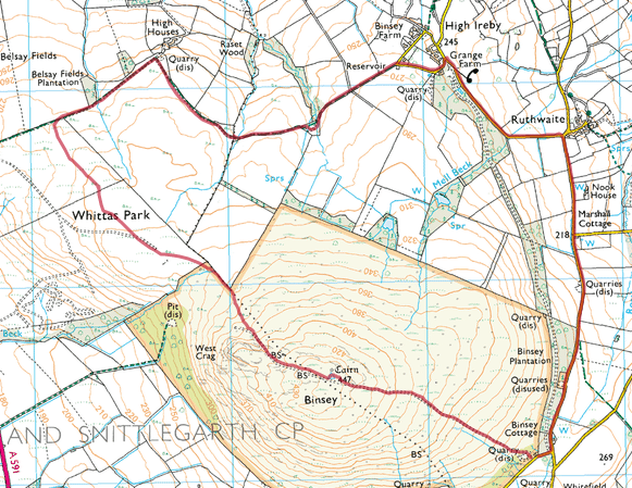 |
| just over 5 miles |
Thursday, July 17, 2014
Skiddaw via Sale How
 |
| looking back from the flat(ish) top of Skiddaw. There's a little trail to the left of the last shelter that cuts off the corner. |
10 miles was on my planner today. I'm continuing to gradually up my weekly mileage. I had heavy legs yesterday on the group run around Binsey and was thinking I would still be feeling it a bit this morning. I've been wanting to test out my Hokas too. I got them a while ago and never really felt good about them. I'm not sure why. A descent down the brutal Skiddaw main path should sort out both issues I thought.
The legs felt a bit better today. I managed to run up to the car park at Latrigg which I would say is the equivalent of the Binsey climb. I then carried on around the Cumbria Way track to Skiddaw House. I was pleased to be able to run all the way around, even if it was at a slow pace.
The climb up Sale How is a slog (although it's very nice in the opposite direction). It brings you out near the top of Skiddaw though and is a nice alternative to the main path. There were plenty of people on top. I circled the summit trig point and then started the run down. I think the Hokas do make this descent easier, my feet were fine on this descent but my legs were aching. I managed the descent at a moderately fast pace, slowing down at Latrigg due to dead legs. Rest day tomorrow. Three Peaks on Saturday!
 |
| Skiddaw from Latrigg car park. There was an ice cream cart there today (the car park) |
 |
| from the gate on the Cumbria Way looking back over Derwent Water |
 |
| nice trail around the back of Skiddaw |
 |
| looking back from the Sale How Climb (I think) Lonscale Pike centre left |
 |
| This is the point where the Sale How track joins the main path, looking back to Skiddaw Little Man (that's the name of the fell, not the little man in the picture) |
 |
| along the top of Skiddaw looking over Longside Edge and Bassenthwaite |
 |
| busy on the top |
 |
| 12.4 miles, 3000ft of climbing |
Wednesday, July 16, 2014
Far Eastern Fell Run
 |
| from Wether Hill looking Westwards. Hallin Fell popping up in the middle in front of Ullswater. The Blencathra range can be seen on the horizon. |
In training for the Cumbria Way, I'm following a plan which basically ups the mileage run, getting ones legs used to running when tired. It's an enjoyable challenge. I sat around on Saturday and eventually slogged out 16 road miles in the rain. On Sunday I had a really nice trail run of about 14 miles. Monday was a rest day and then I had 12 miles on the plan for today. The forecast was good and I had the day off from work so I thought I would head over to the far eastern fells. This is really nice running ground. The route I took didn't have massive climbs. The majority of the climbs were runnable but my plan was to have an easy day and get the miles in.
 |
| just over 12 miles |
I parked at Pooley Bridge and followed the road from the church, crossing over and carrying on until I got onto the open fell. I took a bit of time to get going, walking up the road but eventually broke into a trot up to The Cockpit, a famous Bronze Age stone circle, which acts as a bit of a junction for the various bridleways that cross these hills. From here, I picked up the more direct path to Loadpot Hill, the first Wainwright of the day. Once up here, it is a nice run across to Wether Hill, my furthest point at around six miles in. Neither of these hills are impressive peaks but there is a trig column on Loadpot Hill and a cairn on Wether Hill and the views from both are impressive. I turned around at Wether Hill and ran back, skirting around Loadpot Hill this time. I had intended to visit Bonscale Pike but I was enjoying the track so much that I carried on to Arthur's Pike. Here I chatted to a couple who were enjoying a can of Fosters before carrying on over Brock Crag and back to the entry road.
 |
| Loadpot Hill looking West. Place Fell is in the centre with Helvellyn directly above. St Sunday Crag is clear on the left. |
 |
| from Wether Hill summit cairn looking back on the gentle slope back up to Loadpot Hill |
 |
| at Brock Crag looking over a calm Ullswater |
Thursday, July 10, 2014
Walla Crag Run
 |
| Climbing Cat Gill, looking back on one of my favourite views in the Lakes (with Dawn and David spoiling it) |
Out again with the Wednesday running gang. Jonathan has dubbed us "Hardly Any Climbing" or Hardly AC after my habit of not fully disclosing the impending ascent in order to encourage fuller participation in activities. It was great to have a good turn out again and hopefully the little group will continue to grow and we will continue to have a laugh. I had a really great time. This is a great group of people and my hill climbing skills were definitely impeded through the act of laughing out loud.
This week's route was one of my favourites: around Walla Crag. Parking at Great Wood NT car park, we climbed up Cat Gill then headed over to the summit. We set a good pace which continued all the way around. After admiring the views from the top, we continued on the path (it's a path on the map) down the hill to the road turning left into Spring Woods for more downhill joy before coming out at the cafe. We then ran along the road for a bit before turning off towards Castle Head, a cheeky little climb but a great viewpoint.
From here we headed over to the shoreline path and followed it the last half mile or so back to the car park.
 |
| I managed to get to the top of Walla Crag before the crowds |
 |
| here they are though |
 |
| and again at Castlehead viewpoint |
Next week Binsey. Come and join us.
Yewbarrow
 |
| from the road |
Heavy legs today after building up my running mileage so I capped this run/walk off after Yewbarrow and circled back around along Overbeck back to Overbeck Bridge car park. I started with an ascent from the car park directly up the south side coming out at Great Door then continuing the half mile to the summit. I carried on along the top, dropping down Stirrup Crag to Dore Head where I turned south along the valley.
 |
| 5 miles |
 |
| steep path alongside the wall - Bell Rib is ahead |
 |
| picking a path up through Dropping Crag |
 |
| Great Door looking over the east end of Wast Water to Scafell |
 |
| back towards the screes |
 |
| from the summit Scafell Pike and Scafell with a lot of cloud hanging over them |
 |
| over towards Red Pike and Pillar. Wind Gap scree path can be seen centre left |
 |
| looking back towards the summit |
 |
| from the North Cairn - Wasdale Giants |
 |
| this is back around to the wall I climbed up. A panoramic view of Wast Water, the screes and the Scafells |
 |
| closer in on the screes |
Subscribe to:
Posts (Atom)