Saturday, December 28, 2013

Hen Comb - Dec 2013

from the summit looking over towards Buttermere with Red Pike in cloud

easy walking

Without wanting to go on about it, I've been unwell.  So unwell that I visited the doctor yesterday, having suffered intolerable headaches for over two weeks.  The medical advice was to take it easy and carry on taking the tablets.  A trial run on Monday had confirmed that I am by no means fit to exercise strenuously and so today, with a bit of time and some decent weather at last, I headed out to walk up an easy fell.

Hen Comb was one of the last fells I bagged on my first round of the Wainwrights.  As Wainwright said, it suffers somewhat from being a neighbour of Mellbreak, a much more impressive fell.  Mellbreak is surrounded by streams: Whiteoak Beck and Mosedale Beck.  Wainwright comments that it is the only fell that can be impossible to summit after heavy rainfall.  There is a bridge over the Mosedale Beck, near to the Mosedale Holly Tree, but at the start of the walk, if you attack it in the usual way from Loweswater, you have to get over one or other of the becks.

I parked at Maggie's Bridge car park.  It was already full on my arrival at about 10.30am but I managed to squeeze my little car into the side of the track.  I headed off towards Watergate Farm, following the track along the river until I got to the wall above Nook Farm where the open fell begins.  From here I traversed east along the wall, down and over Whiteoak Beck (some skilful balancing on a log across the beck) and then climbed to the ridge which I followed to the top.  It was a bit wet but I slogged out the hills until I was at the summit cairn.  Here I took a number of pictures in different directions before heading off the steep end, initially along the path to Flouten Tarn before heading off more directly aiming for the bridge over Mosedale Beck.  This was a steep but manageable descent.  Once on the track it was an easy and level walk back to the car.

Just as I was approaching my car, the famously grumpy Loweswater farmer came up behind me in his landrover, beeping his horn.  I stepped aside to let him past and he pulled up along side me and wound down his window and shouted, "If you didn't have those f@*%ing things in your ears, you might be able to hear."  I took one earphone out of my ear and said, "pardon?"  He didn't like this but repeated himself.  I think he was astounded by my response, "yes, you're right."  He sat there for a while, glaring at me.  "Is that all?" I said.  After a while, I put my earphone back in and he drove off.  He had obviously had a rough morning.


summit shots: towards Starling Dodd middle right and the ridge to Red Pike on the left

over to Great Bourne and Herdus

Blake Fell and Carling Knott

Mellbreak north top popping out with Whiteside behind.  Low Fell on the left

Fleetwith Pike in the middle, Dale Head to the left, then Robinson.  Red Pike on the right.

and the Mosedale Holly Tree on the flanks of Mellbreak.


Monday, December 16, 2013

Sale Fell - Dec 2013

Tonight's route

After a man-flu enforced lay off, it was nice to get out again this evening after work.  I set off from the usual parking spot, taking the clockwise path to the summit.  This route has steep initial climbs to the summit and then follows a nice downhill along to the nose.  I took the descent easy tonight as it was dark and not easy to pick out the path.  I usually turn right at the wall and continue descending to the road but tonight I went left and looped around on the path through the woods.  I tried the higher path in the woods (which I later found out is a Strava segment) but the fallen trees are still there.  It looks like a path has been made around them but I didn't fancy venturing into the trees on a makeshift path in the dark so I turned around and carried on the lower path.  Coming out of the woods, I fancied another loop up to the top but my toes were rubbing together a bit and I think it was a wise choice to avoid a blister and head back down the way I came up.  I put a few short hill repeats in to take the total distance up to 5 miles before finishing.

No pictures - it was dark.


Saturday, November 30, 2013

Half of the Ennerdale Horseshoe

on a frozen Red Pike.  The dip on the horizon is Wind Gap between Pillar on the left and Black Crag on the right.  Haycock is the fell on the far right.  Scafell Pike and Scafell are visible through the gap on the left.

plenty of climbing - 22.2 miles

Well I did the other half a few weeks ago.  We had planned to do the whole horseshoe but we ran out of time and energy and so decided to come back along the valley floor path.  Great weather today, a touch of frost, very little wind and cool.  Perfect fell running conditions.  It did start to get a bit cool as we got up on to Green Gable but all in all I have no complaints.

It was frosty on the steep climb up to Great Borne but a nice run down and around Starling Dodd to pick up the Red Pike path.  We went around to the south of High Stile and then picked up the rocky ridge along to the steep descent down Gamlin End.

dead flat Ennerdale Water from near the start

from Great Borne looking down Ennerdale

from Red Pike looking over to Grasmoor, Whiteless Pike and others across Crummock Water

and another looking over to Melbreak on the left.  Look at the shadow cost by Red Pike!

trying to pick out the best way around High Stile

High Crag Summit.  Green Gable is the fell the furthest to the left.  We will be heading up there.

and looking back to High Stile

the descent down Gamlin End, at the end of the High Stile range.  Paul thought he would see what the scree was like

looking back up to that scree descent.  You can just pick out the path winding up to the left of the scree

the further away you get the steeper it looks

We crossed over Seat and started to climb up towards Haystacks before taking a very rough path to the south.  We eventually climbed back up and passed Innominate Tarn and Blackbeck Tarn before trudging on towards Green Gable.  We were both tired at this point and, with a mind on the remaining daylight, it wasn't too much of a negotiation to decided to stop at Green Gable and take the valley floor path back to the car.

Blackbeck Tarn looking up to Green Gable and Great Gable

looking back towards Haystacks and High Crag behind.

looking up at Pillar Rock from the valley floor

almost there now, a good 10 miles from the turn around point at Green Gable.  Here we are looking over to Anglers Crag on Crag Fell which would have been the last fell if we had done the whole route.

Saturday, November 23, 2013

Playing with the 1st Leg of the Bob Graham Round

at the last fence on the climb up to Skiddaw, looking back at Little Man

A nice long run out today on a classic route.  Snowy and icy conditions meant that a descent from Hall's Fell Ridge was not wise so we took a route back to Keswick down the gentler slopes of Blease Fell.  Twenty miles all in all (although I did wind through the streets of Keswick to make up the last mile).

route and elevation

climbing up to Skiddaw, looking over the Coledale fells.

My aim was to keep at a low heart rate as much as possible for this run.  I've worked out that it's a lot harder to pace yourself when you are out with somebody else.  There is a real tendency to race.  Jonathan would get ahead and then I would try to keep up.

We took it very easy up to Latrigg, walking the steeper sections.  Once we got on the main Skiddaw path, Jonathan couldn't help surging ahead.  I thought that we went up Skiddaw a bit too quick for the long run we were planning but we got up pretty easily.

As we were climbing, the top was clear but when we got to the top, it was a whiteout.  Icily cold, we didn't hang around on the summit, carrying on straight over to pick up the track down the fence line.  I slightly overshot the turn off but not by very much and we were soon descending the tracks over to Hare Crag.

I was surprised to find so much of a track, expecting this section to be just a grassy trod.  We soon dropped down out of the cloud but there was plenty of snow and ice around, making the going quite precarious.  We took our time, gently following the track down and over.  It got boggy as the terrain levelled out.  The ground was partially frozen.  Just about enough to not sink if you were going fast but we both still got our feet wet and boggy at this stage.

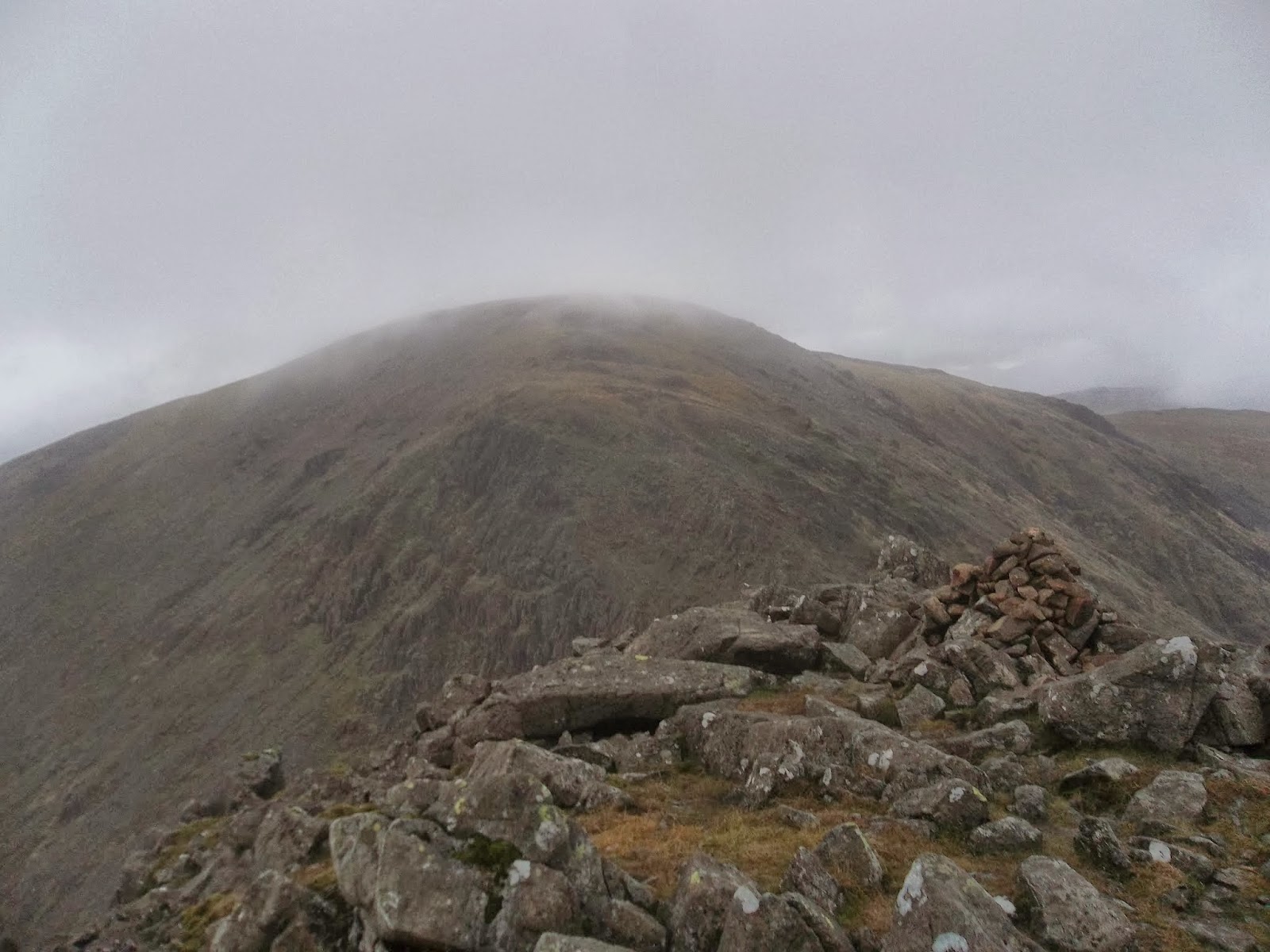
At the Grouse Butts, I thought about heading over to take the more mellow ascent of Great Calva but decided to carry on straight across.  The path was much better than it looked and we steadily climbed to the summit, taking in a bit of food on the way up.

At Great Calva Summit, we turned around and started to follow the fence back down, around the corner to the East.  In hindsight, we might have been better continuing down here to the Cumbria Way track because the route we changed to after consulting the map was across deep heather which took up lots of energy.

We ended up at the circular sheep pen, then trudged 100m or so to find the river to be quite fast and quite deep.  We thought about jumping at one point but the water was very deep and so we walked south west to where the fence crosses the river, using this as a handrail.

Great Calva summit, looking back down the fence line

Mungrisdale Common
Once over the river, we had the steady trudge up to Mungrisdale Common.  Slow and steady again and with wet feet from the boggy ground before the river.

We eventually reached the rounded top and found the summit cairn without difficulty, continuing on to the back of Blencathra.

This, normally boggy, section was just the right amount of frozen to stop us sinking.  At this point, we had a think about remaining daylight hours and energy levels and decided to head down to the Keswick railway track once we had been over Blencathra.

At Foule Crag we put our microspikes on and climbed up to the flat top, running across to the summit.

just before the microspikes went on - heading up to Blencathra

easy running across the frozen top


the final climb

At the top, we walked over to look at the Hall's Fell path and I don't think Jonathan was in any doubt about my decision to avoid it today.

We carried on along the tops over Knowe Crags and then enjoyed the long and winding descent down Blease Fell.

We took a slightly convoluted route through to the railway track and then enjoyed an easy run back to the car.


Friday, November 22, 2013

Fixing Gowbarrow Fell

From the top of Gowbarrow Fell

Today I took part in a Fix the Fells work party.  It was a muddy affair on Gowbarrow Fell.  There is a path under construction, using quarry waste from Threlkeld.  The path is a nice surface but it finds the natural dips in the landscape, then these fill with water, then people walk around the water creating wider and additional paths.  Today we were spending time fixing some of these dips in the path as well as diverting water from the path by digging a long drainage ditch along the side of the path.

It was a lovely day to be out.  There were 17 volunteers plus park rangers and some bigwigs from the National Park and we all got stuck in.

 
I had a go with Peak Scanner, a new App on my iphone.  The idea is that you point it at a fell and it tells you about it.  It worked better than I expected, picking up Arthur's Pike and not doing too bad on Little Mell Fell (which is the left hand mound in the picture above.

Saturday, November 16, 2013

Ennerdale Run

up on the climb up to Pillar.  An early start today meant that I ran along the valley floor and got to about here before it was light enough to take my headtorch off.

a bit of light
I wanted to get a decent length run in today.  I also needed to be home for 2pm so that meant that I would need an early start.  There were rumours of cloud inversions but they were not to come true.  Most of the run was done in cloud.  Luckily, there is a wall that runs along much of the route I was taking so the navigation was easy enough.  My run started at about 5.20am with the first six or so miles done in the dark.  I got to Black Sail Youth Hostel and decided it was still a bit dark to be climbing up Black Sail Pass and so I sat on the toilet for ten minutes.  On emerging, I picked up the track, which is fairly easy to follow and when I got to the footbridge, decided to just continue up along Sail Beck, eventually reaching the familiar fence posts.  By now it was starting to get lighter and I took the track over to Pillar.  Pillar looked the most promising out of the whole day for cloud inversions.  When I got to the top though, it was within the cloud and so there was not a whole lot to see.

Yewbarrow and Dorehead Scree on the right

Pillar - cloudy and bland today

On top of Pillar, I sat in the shelter and took a compass bearing to take me over to Wind Gap.  Once up at Scoat Fell, I picked up the wall which I followed for the remainder of the high level portion of the route along to Haycock, Caw Fell and around until I got to the forest (which has all been logged) and the climb up to Crag Fell.  It was pretty much misty all the way but good terrain for running.

Mosedale opening up a bit, just before I reach Wind Gap

Black Crag looking up to Scoat Fell

Scoat Fell wall summit cairn

Haycock
scenic

my wall


Grike and Crag Fell ahead (on the map there is a forest there but all the tress have been chopped down).

Crag Fell looking over to Grike

Grike

Grike was at the 16 mile mark.  From here there is a nice downhill to Ennerdale Bridge and then I ran along the road, cutting through on a footpath to follow the shore line for the last six miles back to my car.

map with elevation data